The equipment used to measure the altitude of an object above a fixed level (i.e., sea level) is known as an Altimeter. A major application is determining the height of an airplane flying above the earth to avoid obstacles such as mountains and other airplanes. Moreover, it’s advisable to fly at a high altitude due to the thinner air, which requires less fuel as it asserts less resistance. This optimal region can be found by knowing the altitude level. The Altimeter is used to measure altitude and is widely used in the avionics domain. This page explores methods to measure altitude, vendors and benefits of altitude indicator.
There are two main methods to measure altitude:
Methods to Measure Altitude
Method 1: Measure air pressure and determine altitude from this.
This method relies on the principle that air pressure decreases with increasing altitude. By measuring the air pressure surrounding the aircraft, the altimeter can calculate the corresponding altitude.
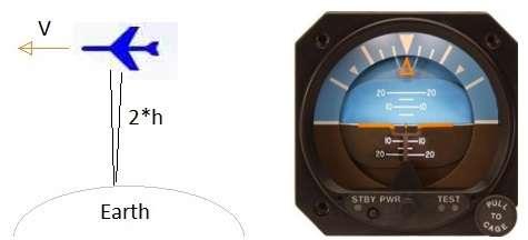
Method 2: Transmit a radio frequency wave from the airplane towards the earth and measure the round trip time.
We know that radio waves travel at the speed of light (approximately 3 x 10^8 m/sec). By measuring the time it takes for the radio wave to travel to the ground and back, we can calculate the distance, which gives us the height of the airplane above the earth. The figure above visually explains this concept.
The most common altimeters used in avionics are known as aneroid barometers. They display height by measuring pressure. This type of altimeter uses a hollow box that expands and contracts based on pressure decrease and increase. This movement consecutively moves the pointer based on the change in air pressure.
Vendors of Altimeter or Altitude Indicator
The following are some of the vendors of altimeters or altitude indicators:
- HTC AL-7000 (measuring range: 0-5000 meters/580-1040 hpa)
- Swastik Scientific Company, MUMBAI, INDIA
- L.J. Engineering, Inc. CA
- Apex Instruments, Inc., NC
- RIEGL, FL, USA
Benefits of Altitude Indicator (i.e. Altimeter)
Following are some of the advantages of altimeter.
- Provides real time altitude readings, helping pilots maintain a safe flight level and avoid terrain or obstacles.
- Enables pilots to fly in low visibility conditions by ensuring proper altitude separation and adherence to flight plans.
- Used in meteorology to study atmospheric pressure changes and predict weather patterns.
- Helps mountaineers, hikers, and skydivers track altitude for safety and navigation.
- Assists air traffic controllers (ATCs) in managing altitude separation between aircraft to prevent mid air collisions.
- Used in spacecraft and military aircraft for precise altitude measurement in high altitude missions.
- Helps unmanned aerial vehicles (UAVs) maintain stable flight and comply with altitude regulations.
- Pilots use altitude data to optimize fuel consumption by selecting the most efficient cruising altitude.
- Comes in different types such as barometric, radar, and GPS-based altimeters, each suited for specific applications.
Conclusion
The altitude indicator (altimeter) is a vital instrument across aviation, meteorology and outdoor activities, ensuring accurate altitude measurement for safety and efficiency. In aviation, it helps pilots maintain proper flight levels, aids in collision avoidance, and supports instrument based navigation. Beyond aviation, it plays a crucial role in weather monitoring, adventure sports and drone operations. With advancements in technology, modern altimeters offer improved precision and integration with GPS and digital systems. Whether in aircraft, space missions or mountaineering, the altitude indicator remains indispensable for accurate altitude tracking and operational success.